PHOTO LINKS:- Album Guanaja Part 1 https://photos.app.goo.gl/efrubyz28RSPu6VC9
Part 2 https://photos.app.goo.gl/94QhUxrb6jHuMmJr9

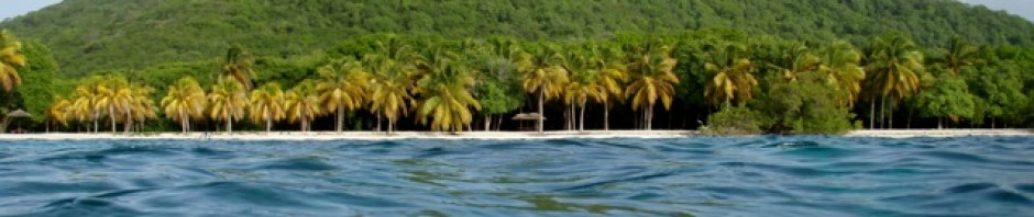
Our visit to Guanaja two and a half years previously had been quite brief, but at that time we were intrigued by the island. They say Christopher Columbus “discovered” Isla Guanaja on July 30, 1502, on his fourth and final voyage of discovery, so legend says. Columbus was met by large dugout canoes carrying 25 Mayan Indians in each and was quickly welcomed ashore. He found excellent water and noted that he had, “never tasted water of better quality.” The island was so covered in pine trees that Columbus initially named the island Pine Island.


We had a lovely sail from Port Royal to Guanaja, arriving in the mid afternoon we found just 2 other sailboats there and they looked like permanent residents. We went ashore to Hans’s place which was ahead of us in the anchorage. He seemed friendly and granted permission to us to use his “dock” to leave our dinghy the next day.
The Blue Dot Trail

The following day we left the dinghy and set off to find the blue dot trail which apparently would lead us towards the top of the island, past the water dam and around in a circuit of about a 3 – 4 hour hike.

As we left from Hans’s place we were joined by a very cute little brown dog, who we later found out his name was Bobby.

This cute little fellow accompanied us for our entire adventure often taking off to chase what ever he spied along the way. Well to start we had to find the trail, this took some hunting and some asking of the few folks we saw on our way.

Finally we were off uphill, on the blue dot trail. It was a lovely, but steep and rugged uphill climb. At stages ropes were tied to help pull oneself up the steepest, slippery party, but the way was shaded and the views downward were wonderful.

Once up the steep side we reached the dam. This is the dam for the main water supply to the island. Guanaja is an unusual island as it has natural water springs. The water bubbles and flows from springs in the highland and supplies the people with wonderful, natural, pure water.

Onward and upward we were basically walking the ridge line from one top to the next and the next. We had to really hunt for the blue dots as the trail was very over grown from not being over used.

I found that the grasses that were covering the trail were a kind of razor/sedge grass and soon my bare legs were covered in fine cuts. So what with all the no-see-um bites from lower down and the razor cuts my legs were quite a mess – note to self – wear long socks or pants in future.

John was often way ahead as I would be distracted by the views and taking pictures at every turn. It was our first good hike for a very long time, and just so enjoyable scrambling about on the slopes.

The trees on Guanaja are very unusual for the region as they are pine, a special pine that grows on Guanaja.

The whole island used to be thickly forested until hurricane Mitch blew through in 1998 at reportedly 200mph for 2 hours, when quite a number of the trees were stripped bare and lost. However the slopes have more or less re-forested and the pines are very much there again.

After 2 hours we were at what was or seemed to be the highest point around. We had a choice either to continue and have faith that the trail would be a circuit as we had been told, or to retrace our steps. I chose to continue following the trail so onward we went gambling we were on the homeward route.

Sure enough, we soon found that the route did swing towards the correct direction and we started a steep, downward slope arriving at the dam from the other direction.

Once at the dam we dangled our feet in the cool water and rested for a while. Once we were at the bottom we found the whole venture had taken us just under 4 hours which was a good time seeing as we had quite often lost the trail and had to hunt for it.

Off to the waterfalls, La Casscada

The next big venture was to the waterfalls. To get there we had to travel by dinghy towards Bonacca where there is a canal that cuts from one side of Guanaja to the other. This canal is quite deep and lined by mangroves. Once through the canal we travelled up the shoreline towards Michael Rock.

Past Michael Rock we proceeded to hunt for the correct landing spot. We actually ended up nearly at Mangrove Bight at the other end of Guanaja. So we back tracked slowly along the shoreline looking for an outlet from a river as where there are falls there has to be a river and a river has a mouth. We spotted the small river mouth and believe it or not a rare sign announcing La Casscada – waterfalls.

Off along what we took for the path beside the river we headed towards the falls. It was a lovely riverside trail, slippery in places, not very well marked and often we had to cross to find a way forward.


I just waded as trying to keep my feet dry seemed silly. We did reach an area which I believe they call the lower falls, but there we were confronted by huge boulders to get around with a drop below onto other boulders.


There was a line attached to use, but we both decided that the risk of injury out weighed the necessity of reaching the big falls. Maybe if there were others with us we would have ventured on, but we were a long way from the boat or help. So we enjoyed the lower falls and the adventure and headed back.

On our way in the dinghy along the shoreline we enjoyed the scenery and stopped off at an old dock near the Columbus monument to walk the shoreline for a stretch and a snack in the shade of a tree.

You need to be careful where you sit in the wilds of Guanaja as we found out – there are ticks. John had spotted one on the little dog the previous day and then we both found a few on ourselves.


Along the canal to the Western end.

Another great venture was when we again travelled through the canal to the other side and explored along the shore line of the western end.

We firstly locked the dinghy to a tree of the first beach of the western end. Here we spotted a pathway and a sign announcing that the area was a reserve. Off along the path we trod, first facing a very rugged way up a washed out hillside path.


Finally at the top we found beautiful views, but another sign saying that the way ahead was private property.

John really wanted to continue, but in the other direction up to a ridge line along the top of steep hillsides to the highest point we could see in the distance. I just felt that as my legs were so beaten up from the razor grass that I did not want to go. Plus the whole plan had been to explore the shoreline. So back to the dinghy we headed.


The shoreline here is very rugged in places and just beautiful. The reefs looked to be excellent for snorkeling, the water just crystal clear and turquoise blue.

Once we were further along the West End Bay we walked along the 2 mile beach enjoying the sunny day.


Afterwards we had a snack lunch and returned down the canal to Aeeshah.
Savannah Bight?

One of the days we tried to get to Savannah Bight via a pathway we had been told ran along the shoreline. We managed to walk as far as a small farm and then the pathway was blocked by the farmyard and rubble.

So we doubled back to the peninsular, past some very nice homes and looked along the shore for an alternative route, asked a local and concluded there is no path to Savannah Bight. So we decided to go in the dinghy along the shore to the settlement.


The dinghy ride was very lumpy as we were going into the wind, but after about half an hour we were there. And what was there? Not much, mainly fishing boats and large supply boats which were in the process of docking on the shoreline.

We decided to just cruise around and leave, there was just nowhere to land the dinghy anyway.

We cruised back along the shoreline enjoying the scenery.

Mia Cassa Too:

is a restaurant on the hill above the bay where the anchorage is located.

This restaurant serves the most delicious food and has wonderful views over the anchorage. We visited twice and both times had the Lion fish.

The view form there in the evening is lovely too, plus they have a hummingbird feeder. Unfortunately the hummingbirds proved to be quite camera shy.

Our second visit we were in the company of a number of other cruisers. 5 of which were off a boat that had just arrived. They left the following night and wrecked the boat on the reefs off French Cay…….but thats a story for the next blog to follow…….

Bonacca

Supply shopping is always an adventure because you have to take the dinghy across the anchorage to the town/island of Bonacca.

This is one of the strangest islands of all, most of the population live on it and it is a maze of buildings, sometimes compared to Venice.


There are no streets, and no cars or scooters, even bicycles are prohibited. Everyone walks along sidewalks, pathways down narrow alleyways. Many of the homes and businesses are on stilts out over the water some being three stories high. Just about everything you might need can be found in Bonacca if you are willing to look or ask. The locals all speak English, so it is easy to interact.

 Now why would the majority of the population live on this small island while there is a huge main island? Well, in days gone by the locals found that the no-see-ums, the biting bugs were just too vicious and plentiful on the main island.

And so they mainly inhabited the little sister island. And if you ever experience the bites of the no-see-ums that are on the main island you would agree.

Walking around Bonacca is like a test of directional navigation, it is not large, but set out like a winding maze of alleyways and water ways through and around the buildings. Supply boat day is the day to shop and the island is busy with the men using carts to deliver the goods and shoppers getting supplies while they last.

Earthquake
One morning I arose around 6:30 or so, went into the head, just sat on the toilet when….. The whole boat sounded like it was hit by something. There was a rumbling sound and a sensation of a shaking. I went as fast as possible to the cockpit to see what the heck had happened …… there was nothing there. I was really puzzled, what had happened?

A while later I heard from a fellow cruiser that they had felt it and thought it was an earthquake. Sure enough when John awake and looked online he found it was a quake, not far from us, under the sea.
Pelican Walk

Our last venture was to walk the shoreline from the anchorage to the other small settlement at Pelican Walk. This was a really fun walk.


We started following small pathways along the shoreline, past homes and abandoned buildings, sometimes even through a property. The pathway then climbed up at slope and continued along a shelf of a steep hillside above the water, one slip and on the rocks below you’d find yourself.


Once down the path we were at the beginning of the settlement. Along Pelican walk we passed homes on the seaward side standing on stilts, guessing to avoid the bugs.


On the landward side we saw children and youths in uniform having left a school on the hillside.


We stopped to chat to folks and continued to what we think was the end as we could not continue any further without passing through gates.

On the way back we stopped along the pathway amongst some mangroves to chat to a fellow. Within all of 2 minutes we were slaughtered by the no-see-ums.


Guanaja really is a beautiful, unspoiled treasure which I would happily visit again.

A Guanaja sunset
Go back? He thought. No, good at all! Go sideways? Impossible! Go forward? Only thing to do! On we go! – JRR Tolkien
Like all explorers, we are drawn to discover what’s waiting out there without knowing yet if we have the courage to face it. – Pema Chodron