PHOTOS LINK —>> https://photos.app.goo.gl/nRSNofkZpu45lPmA2
The ICW Jekyll and Cumberland Islands

We were said to say goodbye to our friends but we were very happy to be heading out from Brunswick and onto our next adventure.
The ICW was our route of choice towards Florida. The first part of the ICW was passing through Jekyll Creek at mile marker 684. Here the water is very thin/shallow, as the creek is known for its shallow shoals. We had timed our passage so as to be moving on the rising tide, (Tides here are up to 7 feet), that way we had plenty of water under the keel.

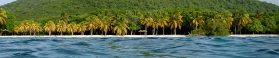
Jekyll Island
Arriving at our anchorage across from Jekyll Island marina just after lunch meant we were able to go ashore for a walk and to explore.

We headed down a wooded trail towards the Atlantic shoreline where we deceived to walk the beach. It was a cool windy day, the tide was low and the walk was exhilarating. There were many Horseshoe Crabs lying on the beach where they had been washed ashore, some of them were just huge!

We met a ranger from the Jekyll island turtle/ reptile project. She was hunting in the shoreline-wooded debris and carrying a huge antenna. Asking her what she was hunting, I was surprised to hear, “Georgia Diamond Back snakes”. Apparently there was a female within 5 feet and she was checking on her. They keep records and research the snake population of Jekyll Island, as they are quite unique. We had an excellent few hours ashore and returned just in time as our dingy was nearly stranded in the mud with the low tide.

Setting off early again our next destination was Cumberland Island.
Cumberland Island

I had read about Cumberland Island and its wild horses and really hoped to visit. It was an early 7:00am start as we had a good 20 miles of the ICW to cover before the end of the day.

Most of this stretch of the ICW is through extensive marshlands as the canal just winds and twists its way along it is wild and lovely. Before we reached the northern end of Cumberland Island we had to cross the St. Andrews Sound and to avoid the shoals and bars our track lead us quite far outside and the back into the sound next to the north of Cumberland Island. Just after noon we reached Cumberland Sound where we anchored near the National Park and Sea Camp Ranger Station of Cumberland Island.

Cumberland Island National Seashore is Georgia’s largest, southernmost barrier island. Congress protected it under the 1964 Wilderness Act. It has 36,000 acres of pristine maritime forests, wild beach, freshwater lakes and saltwater marshes and 9,800 acres of wilderness a magnificent national park.

There are many many species of bird, from Peregrine Falcons to Great Horned Owls to the Rails and Terns. Animals range from bobcat, to raccoon to deer and horses, which the Spanish freed in the 1700s. It is only accessible by boat and has no services except rough camping. Cumberland Island has the largest barrier island wilderness on the East coast of the USA.

We went ashore that first afternoon to have a walk and we’re thrilled to find out that we could take our bikes ashore and ride along the trails. That afternoon however we walked across the island to the Sea Camp Beach and headed north along the beach. And WOW! What a beach, as long as you could see in both directions and wide as the tide was well out.

The next day we went ashore with our bikes and headed south on Cumberland to explore as much of the island as we could in one day.

Stopping at the Ice House we read the history of the Timucuan people who first inhabited the area 2000bc until the British annihilated them and saw some of the artifacts found from these ancients lives.

Our next stop was the Dungeness ruins via the Duck pond and the back entrance. The Dungeness ruins are what are left of a mansion built in 1884 by Thomas Carnegie and his wife Lucy. From the bit of history we read I don’t think the family had much luck as each of their properties burnt down. The ruins look quite dramatic sitting above the water on a slight rise.

We also encountered the Cumberland wild horses in this area of the island; apparently they were released by the Spanish in the 1700s. We had a look at the cemetery where the Carnegie family was buried and passed by other cottages in the southern end of the island.

Our lunch stop was the Sea Camp Station where we relaxed in a rocking chair eating our lunch.

After lunch we set off down the shady lane towards the north stopping first at the Greyfield’s area to have a look. There we followed another lane passed a few cabins that looked deserted and finally coming out at the Little Greyfield’s beach.

We were going to ride north along the beach but the wind was blowing towards us and it would have been a cold hard slog, so we returned inland. We decided to take one of the trails that ran north – the Parallel Trail.

This was quite challenging riding along trails designed for hiking and quite often we had to lift the bikes over the fallen trees. Our aim was to get to Stafford beach, well, we found that the trail seemed to go on forever, finally coming out on the main lane which we then had to follow for a few miles to get to the beach, in other words we took a very long route.

At the beach we rode the bikes south with the wind behind us and it was fabulous! The sun was shining, the wind was blowing and we were whizzing along effortlessly.

The previous day John had seen some huge poles with stainless nuts and bolts attached, he stopped and using the tools he had brought along her helped himself. I just beach combed for shells along the way, finding some nice whelks.

We had a wonderful day on Cumberland and I calculated we rode between 13 and 15 miles.

Fernandina Beach

Our next stop was Fernandina Beach where we got a mooring buoy from the City Marina. Fernandina Beach is a lovely little town, full of old historic buildings like the old historic courthouse and the oldest saloon in the south.

We enjoyed walking the streets seeing the sites. This visit coincided with the day after Thanksgiving and many folks were wearing PJs….. Very odd. After asking we were told that it was a town tradition and as it was a big sales/shopping day you would get an even steeper discount if you wore PJs.

There are 2 paper mills at either end of the town and it was interesting seeing the slow trains run between them and off to the port. Apparently paper is a big industry in this area. I really enjoyed the antique shops with all the different odds and ends.

On our last day there before we set out on our overnight passage we found the farmers market and bought 2 small quiche from “Me Myself and Pies” for our dinner and they were the best quiche we have ever had! If you come across them be sure to buy one!

Aeeshah sailed from Fernandina Beach in the afternoon and arrived in St. Augustine the next morning after a quiet night sail. We did encounter many ships and shrimp boats off of Jacksonville and we even saw the Oleander the Bermuda freighter, but the weather was calm.

St Augustine
John and I found St Augustine to be such a beautiful city. It has a reputation for being one of the most attractive cities in the USA and it really is.

The city has existed for 450 years founded in 1565 by Pedro Menendez de Ayiles. Named St. Augustine because his fleet reached the Florida shores the day of the festival of San Augustin. The city has a colourful history with many historical buildings.

The massive Castillo de San Marcos that was constructed in the 17th century to defend the ocean inlet that allowed entry into the bay. This was our 1st place to visit. The great coquina, (shell stone), fort was built to replace the original wooden fort due to a brutal attack by pirates.

It has high thick stonewalls and is designed with four diamond-shaped bastions to prevent attack from all angles. The 70 cannons are still present facing out to sea and in towards the land to prevent any attacks on all sides. We spent several hours wandering around reading the comprehensive history of the Castillo de San Marcos and St Augustine which the United States took possession of in 1821. St Augustine then became Americanized.


Another very interesting visit was to the Flagler College, formally Hotel Ponce de Leon.

This amazing building was one of many built by Henry Morrison Flagler. He was a self-made millionaire who along with John D Rockefeller founded the Standard Oil Company.

Henry Flagler decided to develop St. Augustine into a winter get away for the rich. He employed the so-called Spanish Renaissance Revival as the architectural style for his huge hotels. This style called for extensive red terracotta ornamentation, red clay roofs, and rounded arches. In 1888 at a cost of $250,000 the Ponce de Leon opened for guests.

Today it functions as the Flagler College and is open for tours twice a day. John and I were very impressed with the Flagler College, the tour was excellent telling the history of the Flagler family, the family and of course the building.

The Tiffany glass windows, all the gilded roofs, artwork and décor are the original and perfectly maintained. The chandeliers are worth over $50,000 each for the small ones, $250,000 for the largest and there are numerous chandeliers.

Our friends Don and Pam arrived and we went together to visit St Augustine Lighthouse and museum. We walked there across the Ponce de Leon Bridge…. Bridge of Lions, to Anastasia Island.

The St. Augustine Light Station is an active lighthouse, and was built in 1874.

We had a very comprehensive tour where we saw the keeper’s house, toured the boat building exhibit, heard all about the history of the area and the lighthouse, plus saw artifacts from shipwrecks off shore St Augustine.


On our return walk we stopped for a lovely ice cream at Wetstone Ice Cream.
The weather was great, but there was no wind to sail down the coast soooo, we decided to do the ICW again.
ICW south

We motored for 53 miles to Daytona Beach where we were shown to a very nice anchorage by our friends Don and Pam on Rainbow’s End.

This journey along the ICW was a very straight forward one compared to our ones in North and South Carolina. The canal is straightforward with few shoals and twists and bends.

There were numerous birds to see in the marshland areas, the houses were interesting to see and most of the traffic was going our way. There were also many dolphins swimming by, playing in the waterways.

The next day was a 37-mile motor to Titusville.
This day we had engine “problems”, the engine was struggling, surging then decreasing, and unable to maintain the steady 5kts that it usually finds easy at 17 hundred rpms. It was quite a worry. We hoped to get a mooring buoy, but none were available, so we anchored. John got his snorkel and mask to go over and see if the growth we had accumulated could account for our problems. What he found was thin blue line from a crab-pot buoy, fishing line and a few barnacles on the shaft and prop. He cleared everything and the next day we found that everything was fine. So somewhere early the previous day we picked up the debris, it wrapped around the shaft and prop and was preventing proper engine performance. We were very relieved.

The next overnight stop was the Banana River, by Dragon’s Head in the Palm Bay region. The passage here was uneventful, along wide waterways, actually quite a boring passage. However when we neared our destination we saw our friends Alan and Claire’s boat Moonstone. So that afternoon they dingied over and we were able to catch up on each other’s news.

Vero Beach
Vero Beach is/was more or less our last stop on the ICW. This time we were able to get a mooring buoy, but when here they raft boats together, up to 3 boats per mooring. We were rafted to Autumn Bourne. Our main concern was Chico and how he would be received and how he would behave. So far all is great, Sue and Dean are a nice quiet couple too and they don’t mind Chico sometimes wandering in to say hello/meow!


Vero Beach is mainly a residential area, very upscale manicured properties that must cost a small fortune. The beach area is just that…a beach area. The marina is very convenient, good laundry, handy free transport and excellent wifi.

John and I have enjoyed riding our bikes each day looking around the neighborhoods and the beach.

Vero Beach is just a weather stop; a deep cold front is passing and then we need wind, but in the correct direction for our next leg south. We will travel the ICW for 12 miles to Fort Pierce, then we sail south along the Atlantic coast to Marathon.
Soon we hope to be off again, heading south ……

“The one thing that you have that nobody else has is you. Your voice, your mind, your story, your vision. So write and draw and build and play and dance and live as only you can.” — Neil Gaiman
