PHOTOS — >>> https://photos.app.goo.gl/QRJe48w5jd1PgkrUA
Puerto Espandio Marina and mooring field,

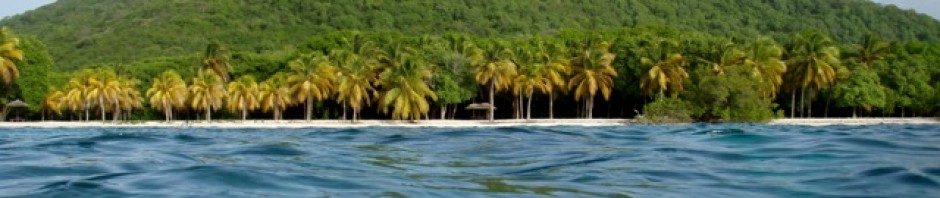
After a roughish passage, we once again we entered the mooring field and checked into the Marina. The mountain view’s were spectacular and a constant reminder of the beauty of the area.


Our days in the mooring field coincided with some exceptionally windy, weather. The cold, winds blasted down off the mountains.

One of the days we didn’t even venture ashore to the marina.


Again I tackled the laundry. This time being lucky with an empty laundry room. We enjoyed a few meals at the restaurant and walks around the marina area.

We hired a car for the day and drove into Loreto to resupply. Again having enough time to walk through the historic zone and have excellent fish and chips at a lovely restaurant.


After 5 days we were ready to leave Puerto Espandido mooring field and resume our southern journey

Agua Verde
“Agua Verde is a remote, scenic fishing village and bay located in Baja California Sur, Mexico, known for its turquoise waters, white sand beaches, and dramatic, mountainous landscape along the Sea of Cortez. It is a popular, secluded destination for adventure travelers, sailors, and campers looking for snorkeling, fishing, and hiking nearby.”

Another post described it as “the land that time forgot”
It is another very large bay with smaller bays inside the main bay. We had one of the beaches in front of us and cliffs along side, plus several other bays off in the distance.

Determined to make the most of our time here we set off the next morning hoping to hike to the cave drawings – petroglyphs that I had read about.

We pulled the dinghy high up on the beach, below where there were a few campers parked and set off up what I guessed was the trail.

After a steady uphill which afforded lovely views of the anchorage, we crested the hill and descended a steep rocky pathway.

At the bottom we found the small graveyard that I had read about. It was the graveyard that was the 1st landmark for this hike. Apparently it was the nearby fishing village’s graveyard. Many of the graves dated back to the early 1900’s.

Setting off again we followed a sandy track that was obviously used by village trucks and cattle. It was through brush with many animal trails leading off into the prickly undergrowth.

We basically guessed which way to go, but we found our next landmark. This was called the oasis, the small green waterway that the area was named after.


Agua Verde – Green Water. The area had obviously been somewhat trampled by cattle, however it was a small green oasis in the middle of dry brush land.


Next we headed to the beach, again it was guesswork which path to follow. By this time it was also quite hot with full sun blazing down on us. We reached the bay and looked for the cliffs where we thought the caves might be……but after hunting we had to concede that we could not find them.


The cliffs and rocks were themselves quite interesting with unique formations. After a short rest we headed back.

The hike back was steep and hot, but again the views were lovely.

Once back at the beach we started chatting to a few of the campers. One fellow told us that to reach the cave paintings we should have walked to the other end of the beach from the oasis and then climb upwards…..oh well, next time.

On our second day at Agua Verde we were awakened around 6:45 by all types of racket coming from the shoreline. Looking out the rocky shore was full of men and boys with white buckets, white boots and fishing gear. I found out later it was a father teach son how to fish event put on by the village Dads. Everybody certainly sounded happy.

After breakfast we headed off from the same beach for a hike up the headland. This was a very pleasant hike and the views across the islands, anchorage and mountains were spectacular.


Parts of the trail were quite rocky but generally speaking it was an easy trail. This day I was hoping to spot the wild mules/burros. We spotted plenty of fresh droppings, heard distant brays, but again they were not spotted.

Mules are integral to the cultural and agricultural of this area of Mexico, within the traditional “ranchero” culture. Due to the rugged, arid terrain, they have historically been preferred over horses because they are better adapted to browse on sparse vegetation.

I really hoped to see the ones we could hear. However, we struck out.


After hiking up to the peak area, we next walked the shoreline of the adjacent isle.


The tide was low and the shoreline easy to walk along. Another lovely outing.

Timbabiche

An anchorage I chose as our next stop. I had read about an abandoned mansion and the story behind it and had hoped to explore the area. Plus there was abundant bird and sea life to be found along the shoreline.

The abandoned, old, manor house has been there since before the Mexican Civil War (1910-1920). The story behind the house was that a fisherman/pearl diver, found a massive pearl and spent his fortune building the manor house for his family.

This is a similar story to John Steinbeck’s, “The Pearl”. And, yes, Steinbeck also travelled this region in the 1940s.

However, not happening, John didn’t feel like getting the dinghy down and going. He chose instead to head off paddle boarding on his own.

I did get to see the mansion in the far distance and some bird and sea-life from a distance too. Hopefully there will be a next time in this lovely anchorage.


San Evaristo

The lovely fishing village was our next stop. We anchored in the main bay with the Sierra de la Giganta mountains behind us.

Off to the shore we headed for a late lunch at our favourite restaurant. Everything was the same as last time. Fishermen were seeing to their boats or cleaning their catches. Hundreds of sea birds of all types were following the fishermen.

We pulled the dinghy up in front of the tiny tienda and went next door to the restaurant for lunch. Both of us had fish tacos which were delicious! After lunch we popped into the tienda and headed back to Aeeshah. We had planned that the next day we were going to head to the cross on the hill, but we headed out instead. The weather dictated that we needed to move on.
San Jose, Bahia Amortajada

Bahía Amortajada, (sometimes referred to as “Chopped-up Bay”), was reputed to be a serene bay, but was known for having a massive mangrove lagoon located on the southwestern tip.

These types of extensive mangrove forests are rare in this part of the Sea of Cortez. They provide a nursery for various marine life and birds.

There were also reports of clouds of biting insects that come out at night, and descend on boats even entering via screens in order to bite human victims. Maybe explaining the Chopped up Bay nickname.
We had decided to anchor some distance from the mangrove lagoon on one of the huge migrating sand bars.

That evening we had a nice breeze and so having the boat semi closed up should have meant we would be safe from the flying biters. However, John got bitten. He managed to get several bites which he said itched like hell. I was spared, maybe because I worn my long pants etc.

Right after breakfast we headed off to explore the lagoon and mangroves. We timed it to coincide with the high slack tide as the cut is impassable otherwise. The channel in was still running water, but was an easy entry.

The mangrove forest as it is called was indeed enormous. We only saw the very outskirts.

There were these large, long fish swimming just under the surface. I believe they were : Needle fish

Needlefish ( Tylosurus crocodilusand ) and cleanerfish (Labroides dimidiatus).
Needlefish (Strongylura): These fish have long, slender bodies and long, thin jaws filled with sharp, needle-like teeth. They are piscivorous, meaning they eat small fish, and are commonly found swimming near the surface in shallow, brackish water of mangroves and coastal bays.

We also spied several large turtles swimming in the shallows.
 And several different species of birds. The most prevalent were the Snowy Egrets. A smaller, active heron with black legs, black bill, and distinct bright yellow feet.

A highlight for me was to see a pair of nesting ospreys in a nest at the far side mouth of the lagoon. They are fish-eating raptors that dive feet-first into the water to catch fish.

Their cry is distinctive and we have often heard and seen ospreys along our route. However this pair just watched us from their nest as we passed.

The area was very peaceful and beautiful.

From leaving the massive, mangrove lagoon we went along the beach shoreline and landed the dinghy. I wanted to visit what had been referred to as the “cactus forest” on San Jose.

Miles and miles of giant cactus. It is a known as remarkable, natural, habitat featuring dense populations of the Mexican Giant Cardón (Pachycereus pringlei), which is the tallest cactus species in the world.

This forest was full giant cacti, which can grow to over 60 feet tall and live for hundreds of years.


However, they do not grow side by side as in a forest of trees, but they support their own ecosystem of plants around them and so are spaced out accordingly. And again, every single plant has thorns.

We followed a wash, an area when it rains water washes out, into the cactus forest.
It was interesting seeing all the differing cactus, and shrubs. Some shrubs were even blooming, others seemingly dried out looking dead.

It was hot, the sandy ground was particularly dry and hot. We saw different animal prints and I wondered how they survived this harsh environment.


After the cactus forest we walked along the lovely beach and returned to Aeeshah. Where we up anchor and departed, heading to nearby:


Isla San Francisco

The anchorage is very popular especially with the charter boats. So as usual there were plenty of other vessels there, many of them large mega cats. We just stopped this time for a bug free night and then headed off.
Ensenada Cardonal, on Isla Partido

We crossed over to Espiritu Santo and Isla Partida deciding to anchor in Ensenada Cardonal, on Isla Partido.
Espiritu Santo, (Holy Spirit Island), and Isla Partida are the two islands that make up the Espiritu Santo Natural Marine Parks a stunning, uninhabited UNESCO World Heritage site near La Paz.

At the very north of them is Los Isotes where there is a sea lion colony. We cruised past slowly trying to see the seal lions and seals from a distance.


Only licensed tour operators are allowed near the Los Isotes. We could hear them barking and Chico was very interested in them.

Ensenada Cardonal was our stop over bay. Another huge bay, shaped similar to a Norwegian fiord with rugged cliffs on either side and a beach at the end.

We had been here before and so our dinghy explorations took us into the neighboring El Cardoncito bay and then onto Partida bay. We passed below very dramatic cliffs and rock formations which really are surreal.

Bahia El Cardoncito was in a deep but shallow bay. We anchored the dinghy off the beach and waded ashore. John went off rocky cliff climbing.


I walked the bay and as usual found some interesting shells. The most wonderful one is a Nautilus shell. It is absolutely amazing how this shell was still intact.

In Bahia Partida we cruised along the shoreline looking at the crazy rock formations and at the lovely bay. To go ashore would have meant a long wade in shallow water, not feeling like doing it, we headed in the dinghy back to Aeeshah.

Falso Bay and La Paz anchorage

Over the next few days we went via Falso Bay and along into the La Paz anchorage. We had just 6 days to prepare for Gavin, Katie and the girls who were visiting……yikes!
“Silent; to be alone. All the being and the doing, expansive, glittering vocal, evaporated; and one shrunk, with a sense of solemnity, to being oneself…When life sank down for a moment, the range of experience seemed limitless.”
— Virginia Woolf
